Ладожское озеро, Карелия, Россия. Открыть в новом окне.
Долгое время я использовал GPSPhotoLinker для записи гео-меток в фотографии. С недавних пор мне надоело, что эта программа зависит от старых библиотек Perl, которые больше не включены по умолчанию в состав OS X. Обходное решение, которое было предложено на форуме производителя софта, решало проблему в течение следующих двух версий OS X. Тем не менее, GPSPhotoLinker стал регулярно падать с RAF-файлами Fujifilm X100T, а также с большими файлами Canon CR2.
По сути, GPSPhotoLinker использует Exiftool для записи геометок. Поэтому я решил написать свой скрипт, который будет подготавливать командную строку для запуска Exiftool с выбранными файлами.

Приложение реализовано как сервис OS X запускается из контекстного меню в Finder. Таким образом, внедрить гео-метки в новые или давно забытые старые снимки легко, как никогда – не надо даже запоминать название приложения 🙂
В принципе, при запуске всё понятно, что делать, тем не менее я прокомментирую каждый этап работы скрипта.

После запуска Geotagger предлагает два варианта: синхронизацию с треками, записанными телефоном или отдельным приёмником GPS, либо ручной ввод координат.

Первый вариант очень прост: всего-то нужно выбрать один или несколько файлов треков (допустим, вы обрабатываете несколько съёмочных дней).

Затем предлагается указать разницу во времени между приёмником GPS (трек) и фотокамерой. Однако лучше выставить правильное время на камере ещё до съёмки.

Второй вариант позволяет ввести координаты вручную, например, для фотографий, сделанных при отключенном приёмнике GPS, либо когда он терял сигнал (пещера или каньон). При первом запуске скрипт подхватит содержимое буфера обмена, а дальше будет предлагать значение, введённое при предыдущем запуске.


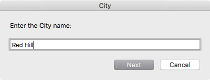

В обоих случаях после выбора файлов трека или ввода координат вручную, вам будет предложено указать текстовые данные о локации, которые записываются в XMP: страну, регион/штат/провинцию, город и сублокацию. Вы можете проигнорировать любое из полей, и тогда соответствующие данные не будут вписаны в файлы изображений. Это удобно, например, когда снимки сделаны в одной стране, но в разных городах. Опять же, эти данные сохраняются до следующего запуска утилиты.
Для вашего удобства ранее введённые данные сохраняются стандартным для OS X способом – в файле plist здесь:
~/Library/Preferences/com.pozhvanov.geotagger.plist
Запросив необходимые данные у пользователя, Geotagger запускает Exiftool с выбранными файлами, а в конце показывает уведомление со статистикой. В дополнение к этому, скрипт проверяет каждый файл на предмет полноты заполнения географических координат и текстовых метаданных в XMP. Если присутствует и то, и то, файлу проставляется зелёная метка. Если файл изображения содержит только лишь координаты или только текстовые данные о локации, то он маркируется жёлтой или серой меткой соответственно. Таким образом можно легко найти файлы, которые требуют работы в индивидуальном порядке.
Скрипт Image Geotagger можно бесплатно скачать в виде ZIP-архива:
Geotag_images.workflow.zip
642 KB.
Распакуйте архив и сохраните здесь:
~/Library/Services/
Включить и отключить контекстное меню Finder можно здесь: > System Preferences > Keyboard > Shortcuts > Services. Удачного геотегинга!
Исходный код
Для вашей уверенности и спокойствия, полный код службы Image Geotagger на AppleScript выложен ниже:
property preferences_file : "com.pozhvanov.geotagger.plist"

property preferences_path : "~/Library/Preferences/"

property exiftool_path : "/usr/local/bin/exiftool"

to SelectInputGPX(title, folder_location)

  set InputGPX to choose file with prompt title default location folder_location with multiple selections allowed

  return InputGPX as list

end SelectInputGPX

on replace_chars(this_text, search_string, replacement_string)

  set AppleScript's text

item delimiters to the search_string

  set the item_list to every text item of this_text

  set AppleScript's text item delimiters to the replacement_string

  set this_text to the item_list as string

  set AppleScript's text item delimiters to ""

  return this_text

end replace_chars

to checkPreferences()

  tell application "System Events"

    if exists file preferences_file of (path to preferences from user domain) then

      return 1

    else

      return 0

    end if

  end tell

end checkPreferences

on run {input, parameters}

  if user locale of (get system info) starts with "ru" then

    set lang to "ru"

    set msg_coord_src to "Выберите источник координат:"

    set msg_coord_src_gpx to "Файл GPX"

    set msg_coord_src_man to "Ввести вручную"

    set msg_select_gpx to "Выберите файл(ы) трека GPX/KML/XML/TCX:"

    set msg_enter_coords to "Введите координаты через пробел (широта долгота высота).

Для ввода координат в западном или южном полушарии используйте знак -.

Значение высоты можно опустить.

Десятичный разделитель – точка.

Чтобы только геокодировать файлы, оставьте поле пустым."

    set msg_enter_coords_title to "Ввод координат вручную"

    set msg_button_next to "Далее"

    set msg_button_cancel to "Отмена"

    set msg_gpx_offset to "Укажите сдвиг времени трека относительно съёмки, если необходимо (HH:MM:SS)"

    set msg_gpx_offset_title to "Сдвиг по времени"

    set msg_enter_country to "Введите название страны:"

    set msg_enter_country_title to "Страна"

    set msg_enter_state to "Введите название региона или штата:"

    set msg_enter_state_title to "Регион/штат/провинция"

    set msg_enter_city to "Введите название города:"

    set msg_enter_city_title to "Город"

    set msg_enter_sublocation to "Введите название локации:"

    set msg_enter_sublocation_title to "Локация"

    set msg_result_1 to "Запись геоданных завершена. Обработано файлов: "

    set msg_result_2 to " Сообщение exiftool: "

  else

    set lang to "en"

    set msg_coord_src to "Select coordinates source:"

    set msg_coord_src_gpx to "GPX file"

    set msg_coord_src_man to "Enter manually"

    set msg_select_gpx to "Select GPX/KML/XML/TCX track file(s):"

    set msg_enter_coords to "Enter coordinates delimited by space (latitude longitude

altitude).

Use - sign to enter coordinates for western or southern hemispheres.

Altitude value could be omitted.

Decimal delimiter is dot.

To only geocode files, leave this field empty."

    set msg_enter_coords_title to "Manual entry of coordinates"

    set msg_button_next to "Next"

    set msg_button_cancel to "Cancel"

    set msg_gpx_offset to "Specify time difference of track to photos, if necessary

(HH:MM:SS)"

    set msg_gpx_offset_title to "Time difference"

    set msg_enter_country to "Enter the Country name:"

    set msg_enter_country_title to "Country"

    set msg_enter_state to "Enter the name of State or Region:"

    set msg_enter_state_title to "State/Region/Province"

    set msg_enter_city to "Enter the City name:"

    set msg_enter_city_title to "City"

    set msg_enter_sublocation to "Enter the Sublocation name:"

    set msg_enter_sublocation_title to "Sublocation"

    set msg_result_1 to "Geodata recording is completed. "

    set msg_result_2 to "

files were processed.

Exiftool output: "

  end if

  set xml_gpx_path to POSIX path of (path to documents folder) as text

  set xml_latitude to ""

  set xml_longitude to ""

  set xml_altitude to ""

  set xml_timeDifference to ""

  set xml_country to ""

  set xml_state to ""

  set xml_city to ""

  set xml_sublocation to ""

  (*  Read preferences from Preferences File  *)

  if checkPreferences() is equal to 1 then

    set the geotag_plist to preferences_path & preferences_file

    tell application "System Events"

      tell property list file geotag_plist

        tell contents

          if exists property list item "gpx_path" then

            set xml_gpx_path to value of property list item "gpx_path"

          end if

          if exists property list item "latitude" then

            set xml_latitude to value of property list item "latitude"

          end if

          if exists property list item "longitude" then

            set xml_longitude to value of property list item "longitude"

          end if

          if exists property list item "altitude" then

            set xml_altitude to value of property list item "altitude"

          end if

          if exists property list item "timeDifference" then

            set xml_timeDifference to value of property list item "timeDifference"

          end if

          if exists property list item "country" then

            set xml_country to value of property list item "country"

          end if

          if exists property list item "state" then

            set xml_state to value of property list item "state"

          end if

          if exists property list item "city" then

            set xml_city to value of property list item "city"

          end if

          if exists property list item "sublocation" then

            set xml_sublocation to value of property list item "sublocation"

          end if

        end tell

      end tell

    end tell

  end if

  set coord_src to display dialog msg_coord_src buttons {msg_coord_src_gpx, msg_coord_src_man} default button msg_coord_src_gpx

  if (button returned of coord_src as string) is equal to msg_coord_src_gpx then

    set gpx_file to SelectInputGPX(msg_select_gpx, xml_gpx_path)

    (*

    if ((time to GMT) / hours > 0) then

      set gpx_offset to "-" & (round

((time to GMT) / hours)) & ":00:00"

    else

      set gpx_offset to "+" & (round

(get (characters 2 thru length of (round (time to GMT))) / hours) &

":00:00")

    end if

    *)

    tell application "Finder"

      set file1 to (item 1 of (gpx_file as list))

      set folder1 to (container of file1) as string

    end tell

    set xml_gpx_path to (POSIX path of folder1) as text

    --    display notification xml_gpx_path

    set gpx_offset to xml_timeDifference

    set gpx_offset to text returned of (display dialog msg_gpx_offset with title msg_gpx_offset_title default answer gpx_offset buttons {msg_button_next, msg_button_cancel} default button msg_button_next cancel button msg_button_cancel)

    set xml_timeDifference to gpx_offset as text

  else

    if (length of xml_latitude < 1 and length of xml_longitude < 1) then

      if (length of (get the clipboard as text)) > 30 then

        set msg_clipboard to ((get characters 1 thru 30 of (get the clipboard as string)) as text)

      else

        set msg_clipboard to get the clipboard as text

      end if

    else

      set msg_clipboard to xml_latitude & " " & xml_longitude & " " & xml_altitude

    end if

    set coord_manual to text returned of (display dialog msg_enter_coords with title msg_enter_coords_title default answer replace_chars(msg_clipboard, ",", "") buttons {msg_button_next, msg_button_cancel} default button msg_button_next cancel button msg_button_cancel)

  end if

  set select_Country to text returned of (display dialog msg_enter_country with title msg_enter_country_title default answer xml_country buttons {msg_button_next, msg_button_cancel} default button msg_button_next cancel button msg_button_cancel)

  set select_State to text returned of (display dialog msg_enter_state with title msg_enter_state_title default answer xml_state buttons {msg_button_next, msg_button_cancel} default button msg_button_next cancel button msg_button_cancel)

  set select_City to text returned of (display dialog msg_enter_city with title msg_enter_city_title default answer xml_city buttons {msg_button_next, msg_button_cancel} default button msg_button_next cancel button msg_button_cancel)

  set select_Sublocation to text returned of (display dialog msg_enter_sublocation with title msg_enter_sublocation_title default answer xml_sublocation buttons {msg_button_next, msg_button_cancel} default button msg_button_next cancel button msg_button_cancel)

  set xmp_Country to select_Country as text

  set xmp_State to select_State as text

  set xmp_City to select_City as text

  set xmp_Sublocation to select_Sublocation as text

  set xml_country to xmp_Country

  set xml_state to xmp_State

  set xml_city to xmp_City

  set xml_sublocation to xmp_Sublocation

  set CommandString to exiftool_path & " -overwrite_original "

  --set CommandString to "exiftool -overwrite_original "

  if (button returned of coord_src as string) is equal to msg_coord_src_gpx then

    if length of gpx_offset as text is greater than 0 then

      set CommandString to (CommandString & "-geosync=\"" & gpx_offset as text) & "\" "

    end if

    if (count of gpx_file) as list is greater than 1 then

      repeat with i in gpx_file as list

        set CommandString to CommandString & "-geotag \"" & POSIX path of (i as string) & "\" "

      end repeat

    else

      set CommandString to CommandString & "-geotag \"" & POSIX path of (gpx_file as string) & "\" "

    end if

  else

    set coord_manual to replace_chars(coord_manual as text, ", ", " ")

    if length of coord_manual > 0 then

      set AppleScript's text item delimiters to " "

      set the coord_list to every text item of coord_manual

      if ((count of coord_list) as list) is greater than 2 then

        set CommandString to (((CommandString & "-exif:GPSLatitude=\"" & (item 1 of coord_list) as text) & "\" -exif:GPSLongitude=\"" & (item 2 of coord_list) as text) & "\" -exif:GPSAltitude=\"" & (item 3 of coord_list) as text) & "\" "

        set xml_latitude to (item 1 of coord_list) as text

        set xml_longitude to (item 2 of coord_list) as text

        set xml_altitude to (item 3 of coord_list) as text

      else

        set CommandString to ((CommandString & "-exif:GPSLatitude=\"" & (item 1 of coord_list) as text) & "\" -exif:GPSLongitude=\"" & (item 2 of coord_list) as text) & "\" "

        set xml_latitude to (item 1 of coord_list) as text

        set xml_longitude to (item 2 of coord_list) as text

      end if

    end if

  end if

  if length of xmp_Country is greater than 0 then

    set CommandString to CommandString & "-xmp:Country=\"" & xmp_Country & "\" "

  end if

  if length of xmp_State is greater than 0 then

    set CommandString to CommandString & "-xmp:State=\"" & xmp_State & "\" "

  end if

  if length of xmp_City is greater than 0 then

    set CommandString to CommandString & "-xmp:City=\"" & xmp_City & "\" "

  end if

  if length of xmp_Sublocation is greater than 0 then

    set CommandString to CommandString & "-xmp:Sublocation=\"" & xmp_Sublocation & "\" "

  end if

  repeat with i in input as list

    set CommandString to CommandString & "\"" & POSIX path of (i as text) & "\" "

  end repeat

  set ScriptResult to do shell script CommandString

  (*  Color label files depending on their geotagging completeness  *)

  repeat with i in input as list

    set counter to 0

    set exifstatus to (do shell script exiftool_path & " -exif:GPSLatitude -exif:GPSLongitude -xmp:Country -xmp:State -xmp:City -xmp:Sublocation \"" & POSIX path of (i as text) & "\"") as text

    if (exifstatus contains "GPS Latitude") and (exifstatus contains "GPS Longitude") then

      set counter to counter + 2

    end if

    if (exifstatus contains "Country") or (exifstatus contains "State") or (exifstatus contains "City") then

      set counter to counter + 1

    end if

    if counter is equal to 3 then

      --green label

      tell application "Finder"

        set thefile to (i as alias)

        set label index of thefile to 6

      end tell

    else if counter is equal to 2 then

      --yellow label

      tell application "Finder"

        set thefile to (i as alias)

        set label index of thefile to 3

      end tell

    else if counter is equal to 1 then

      --grey label

      tell application "Finder"

        set thefile to (i as alias)

        set label index of thefile to 7

      end tell

    end if

  end repeat

  (*  Save preferences in Preferences File  *)

  tell application "System Events"

    set geotag_dictionary to make new property list item with properties {kind:record}

    set geotag_plist to preferences_path & preferences_file

    set this_plist to make new property list file with properties {contents:geotag_dictionary, name:geotag_plist}

    make new property list item at end of property list items of contents of this_plist with properties {kind:string, name:"gpx_path", value:xml_gpx_path}

    make new property list item at end of property list items of contents of this_plist with properties {kind:string, name:"latitude", value:xml_latitude}

    make new property list item at end of property list items of contents of this_plist with properties {kind:string, name:"longitude", value:xml_longitude}

    make new property list item at end of property list items of contents of this_plist with properties {kind:string, name:"altitude", value:xml_altitude}

    make new property list item at end of property list items of contents of this_plist with properties {kind:string, name:"timeDifference", value:xml_timeDifference}

    make new property list item at end of property list items of contents of this_plist with properties {kind:string, name:"country", value:xml_country}

    make new property list item at end of property list items of contents of this_plist with properties {kind:string, name:"state", value:xml_state}

    make new property list item at end of property list items of contents of this_plist with properties {kind:string, name:"city", value:xml_city}

    make new property list item at end of property list items of contents of this_plist with properties {kind:string, name:"sublocation", value:xml_sublocation}

  end tell

  display notification ((msg_result_1 & ((count of input) as list) as text) & msg_result_2 & ScriptResult as text) with title "Geotagger" sound name "Submarine"

  return ScriptResult

end run